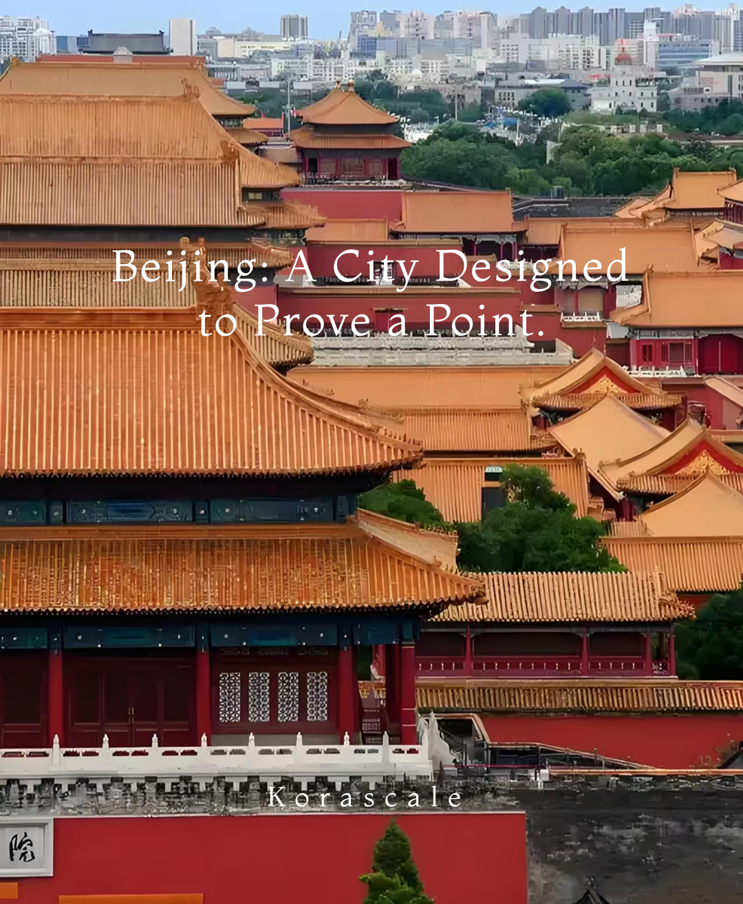
For 700 years, an invisible line has dictated the pulse of Beijing. It isn't just a road or a collection of landmarks; it is a geopolitical blueprint—a 7.8km algorithm that structured an empire.

In 2024, UNESCO recognized the Beijing Central Axis as a World Heritage site, not merely for its age, but because it represents the world’s longest-surviving urban manifestation of an ideal order. At Korascale, we don’t just walk this axis; we decode the hardware that made it possible.

The Idea Before the Bricks: What Is a Central Axis?

Before the first brick of the Forbidden City was laid, there was the Kaogongji (The Record of Trades)—an ancient manual for urban planning. It demanded a city that mirrored the cosmos: "A court in the front, a market in the rear; the ancestral temple on the left, the altar of soil on the right."

  • This is not decorative symmetry. It is a Political Operating System. The Central Axis was designed to place the Emperor at the absolute center of the universe—a fixed point around which the sun, the seasons, and the social hierarchy revolved. To walk the axis is to walk through 2,000 years of Confucian spatial logic.
Beijing's Central Axis: Decoding Imperial Order | UNESCO World Heritage 2024, Forbidden City - Korascale Bespoke Travel

Beijing's Central Axis: Decoding Imperial Order | UNESCO World Heritage 2024, Forbidden City - Korascale Bespoke Travel

The Hard-Core Walk: 15 Components, North to South

Most tourists see fragments; we see a sequence. To understand the "Invisible Spine," you must read it from its rhythmic beginning to its foundational end.

1. The Bell and Drum Towers: The Rhythms of Control

At the northern anchor, these weren't just towers; they were Time-Sync Devices. In an era before digital connectivity, the imperial bells synchronized the movements of millions, dictating when gates opened and when the city slept.

2. Wanning Bridge: The Hidden Connection

A silent witness to the Grand Canal, this bridge is where the city’s terrestrial order met its hydraulic logistics. It is the vital link between the capital's grain supply and its geometric heart.

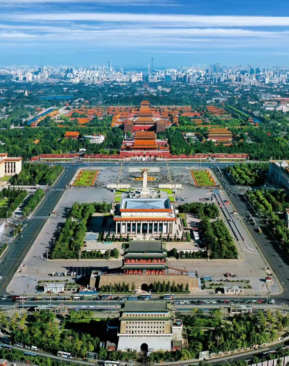
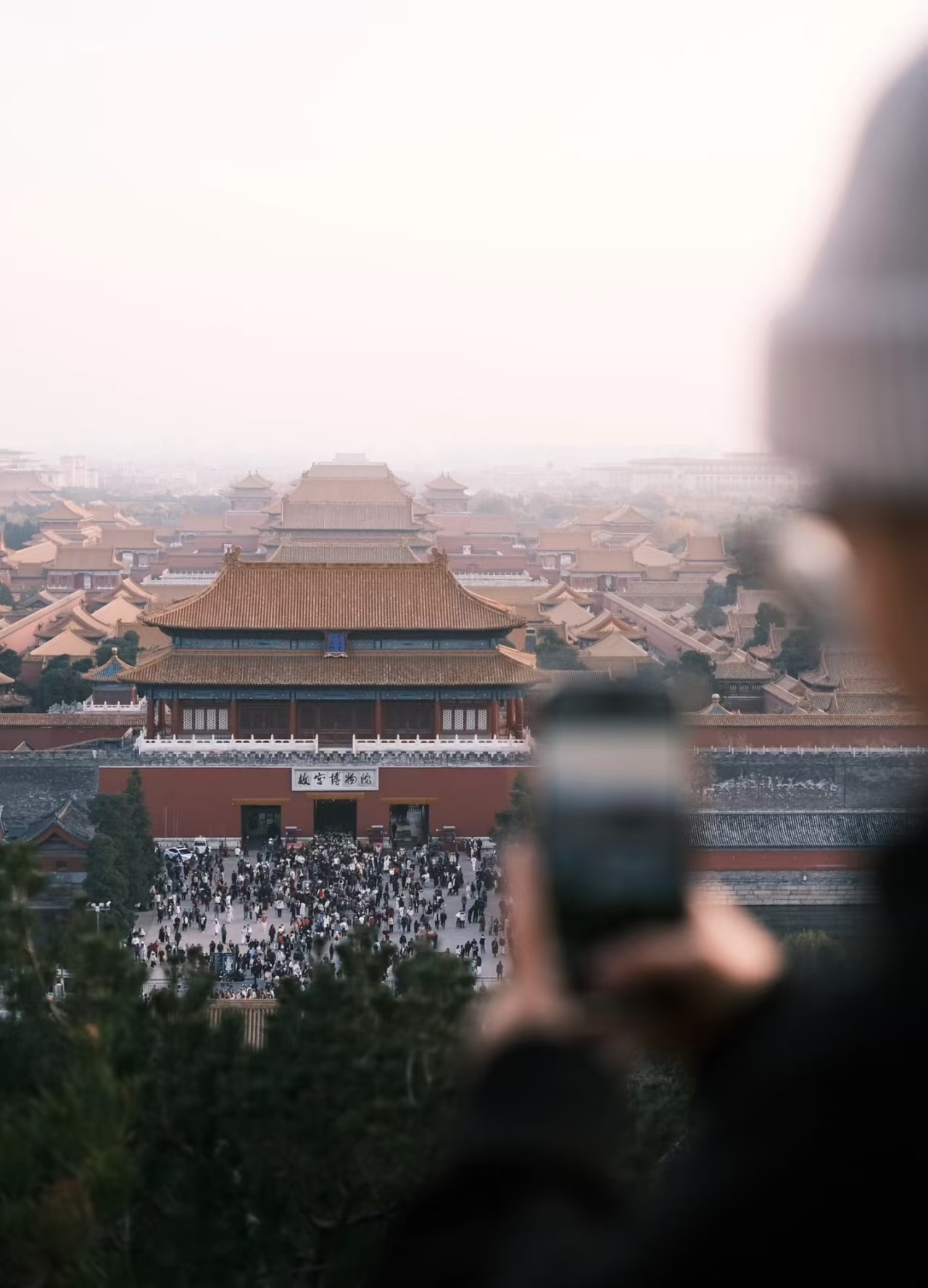
3. Jingshan: The Strategic Overlook

The only man-made peak on the axis. This is the Command Center for your eyes. From here, the Forbidden City reveals its "脊椎骨" (Spine)—a perfect alignment of yellow roofs stretching toward the horizon.

4. The Forbidden City: The CPU of the Axis

At the core sit the three great halls—Taihedian, Zhonghedian, and Baohedian. They are positioned with surgical precision. If the axis is the spine, these halls are the central processors of the empire.

5. Taimiao & Shejitan: The Mirror of Identity

This is the "Left Ancestor, Right Soil" logic in physical form. Most travelers skip these, but they are the keys. They represent the two pillars of power: Lineage (The Past) and Land (The Present).

6. Temple of Heaven & Xiannongtan: The Sacrificial Twin-Poles

  • At the southern end, the axis splits into a dialogue between Heaven and Earth. The Temple of Heaven’s geometry is a mathematical essay on divinity, while Xiannongtan (the Altar of Agriculture) reveals the emperor’s humble duty to the soil.
Jingshan Park panorama of Forbidden City — Beijing Central Axis UNESCO World Heritage 2024 journey with Korascale.

Jingshan Park panorama of Forbidden City — Beijing Central Axis UNESCO World Heritage 2024 journey with Korascale.

Why You Need a Private Guide: The Korascale Difference

The tragedy of the standard tourist experience is fragmentation. Most visitors buy separate tickets, stand in disconnected lines, and see 15 unrelated sites. They miss the "Invisible Spine" entirely.

Korascale treats the Central Axis as a Systemic Continuity. Here is how we redefine the walk:

  • The Dawn Access: We enter the Taimiao (Ancestral Temple) at first light, before the crowds arrive, to experience the spatial silence the Ming emperors intended.
  • The 60-Minute Calibration: We don't just "pass through" Jingshan. We spend an hour at the summit with a culture specialist, using physical maps to decode the north-south logic before you set foot in the palace.
  • The 14th Component: We include Xiannongtan (Altar of Agriculture)—a site ignored by 95% of tour agencies—to show you the complete sacrificial balance of the southern axis.

Strategic Intelligence for your 2026 Visit

Transportation: The best way to "feel" the axis is by bicycle. Rent a shared bike (Meituan/HelloBike) to cover the distance from Yongdingmen to Qianmen.

Security: Beijing's Central Axis is highly regulated. You will pass multiple security checks. Carry your passport at all times.

Timing: Start your walk at 2:00 PM. This times your arrival at Jingshan Park for sunset, giving you the best light to see the "Golden Roofs" of the entire city.

Beijing Central AxisForbidden CityTiananmen SquareTemple of HeavenBell Tower BeijingDrum Tower BeijingJingshan ParkYongding GateKaogongjiImperial Urban Planning ChinaConfucian CosmologyUNESCO World Heritage 2024China 59th World Heritage SiteBeijing Cultural TourLuxury Beijing Private GuideBespoke Travel China

Frequently Asked Questions

Is Beijing's Central Axis a UNESCO World Heritage Site?

˅
Yes — the Beijing Central Axis was formally inscribed on the UNESCO World Heritage List on July 27, 2024, during the 46th session of the World Heritage Committee in New Delhi. It became China's 59th UNESCO World Heritage Site, recognized under the official name "Beijing Central Axis: A Building Ensemble Exhibiting the Ideal Order of the Chinese Capital." The inscription acknowledges the axis's exceptional contribution to the global history of urban planning and its expression of Confucian principles of centrality and harmony. Korascale designs private walking itineraries along the full 7.8-kilometre axis for international travelers seeking to understand Beijing's imperial logic beyond the standard tourist route.

How long is the Beijing Central Axis and what does it include?

˅
The Beijing Central Axis stretches 7.8 kilometres from Yongding Gate at its southern end to the Bell and Drum Towers at its northern end. The inscribed property comprises 15 heritage components covering 589 hectares, including the Forbidden City, Tiananmen Tower, Tiananmen Square, Jingshan Park, the Temple of Heaven, the Imperial Ancestral Temple, the Altar of Land and Grain, Zhengyang Gate, and the Central Axis Road Remains. The axis was established during the Yuan Dynasty in the 13th century and took its definitive form in the 16th century under the Ming. Korascale's full-day private itinerary covers the key nodes south to north, decoding the spatial and philosophical logic at each stop rather than simply checking off landmarks.

Why was Beijing's Central Axis designed on a perfect north-south line?

˅
The north-south orientation of the Central Axis derives from the Kaogongji (Book of Diverse Crafts), written before 221 BCE, which prescribed the ideal layout of a Chinese capital city — court in the front, market in the back, an ancestral temple on the left, and an altar of land and grain on the right, all organized along a central spine aligned to the cardinal directions. This arrangement expressed the emperor's cosmological position as the pivot of heaven and earth — the Son of Heaven ruling from the literal centre of the world. UNESCO recognized this as an "exceptionally well-preserved example of an urban ensemble founded in Confucian principles." For international visitors, understanding this geometry transforms a walk along the axis from a sightseeing exercise into a reading of imperial ideology.

How many days do you need to properly explore Beijing's Central Axis?

˅
The full 7.8-kilometre axis can be walked end to end in under two hours, but understanding it properly requires at least one full day — ideally split across two. A single day should prioritize: morning at Jingshan Park and the Forbidden City (the cosmological and political core), afternoon at the Temple of Heaven (the sacrificial counterpoint to the palace), and early evening at the Bell and Drum Towers (the temporal logic of the northern end). A second day allows for the less-visited southern section — Zhengyang Gate, the Altar of Land and Grain, and Yongding Gate — where the urban planning narrative is most legible. Korascale structures both one-day and two-day private Central Axis itineraries with expert guides who decode the symbolic language of each component rather than narrating historical dates.

What makes Beijing's Central Axis different from other UNESCO sites in Beijing?

˅
Beijing now has eight UNESCO World Heritage Sites, including the Great Wall, the Forbidden City, the Summer Palace, and the Temple of Heaven — several of which are also components of the Central Axis itself. What distinguishes the Central Axis inscription is that it recognizes the connective logic between these sites, not just the sites individually. The axis is the grammar that gives each landmark its meaning: the Forbidden City is significant in part because of its position at the exact centre of the axis; the Temple of Heaven matters because of its symmetrical relationship to the Altar of Agriculture on the opposite side. Korascale's private Beijing itineraries are specifically designed to reveal this relational logic — the Beijing most visitors miss precisely because they visit each site in isolation.